My 8th entry in Amy Johnson Crow’s “52 Ancestors in 52 Weeks” family history blogging challenge for 2015.
The challenge: have one blog post each week devoted to a specific ancestor. It could be a story, a biography, a photograph, an outline of a research problem — anything that focuses on one ancestor.
Amy’s 2015 version of this challenge focuses on a different theme each week.
The theme for week 8 is — Good Deeds. Does this mean a generous ancestor or one you found through land records?
My 8th ancestor is a group of people, rather than a single person. I’m not even sure they are ancestors…. or even relatives. My father’s extended Nieto family is just hoping so very much. This ancestor group is the four heirs of Don Jose Manuel Perez-Nieto (1734-1804), whom I am researching as part of my Manuel Nieto Project.
This week, the focus has been on the history of the Spanish and Mexican land grants.
The Original Nieto Land Grant
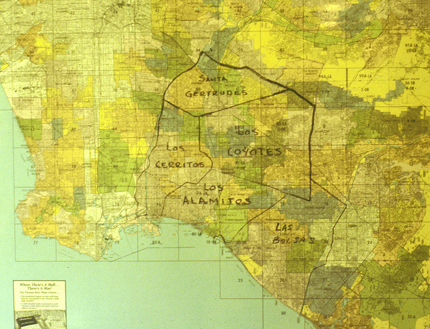
If you recall from a post I did last month (see: King’s Soldier and Alta California Ranchero Manuel Nieto), in November of 1784 retired Spanish Army soldier and 1769 Portolà expedition member Manuel Nieto was awarded the largest, and one of very few, Spanish land grants in Alta California — what would become Rancho Los Nietos, located in present day Los Angeles and Orange Counties. According to Baker, Los Nietos is the second oldest land grant in California, with San Rafael (often called La Zanja) being the oldest.
Milestones in California History claims the original Spanish grant was for 300,000 acres, but was later reduced to 158,000 acres (Wikipedia states 167,000 acres) after the Mission San Gabriel contested the proximity of the rancho boundaries to its own property. According to the Orange County Archives, “It took in all the land between the San Gabriel and Santa Ana rivers, from the foothills to the sea.” Baker says that a total of 158,363 acres was patented when the Mexican regime took over Alta California.
The rancho included all or parts or present-day Anaheim, Artesia, Buena Park, Bolsa Chica, Cerritos, Cypress, Downey, Fullerton, Garden Grove, Huntington Beach, Lakewood, Long Beach, Los Alamitos, Naples, Norwalk, Santa Fe Springs, Seal Beach, Sunset Beach, and Whittier.
According to Milestones in California History and Engstrand, Manuel Nieto’s heirs inherited the rancho upon his death in 1804. In 1833, these heirs requested that the Mexican Governor divide up the land among them, which was done in 1834 when the land was regranted by the Mexican government.
Baker states that when the U.S. acquired California following the Treaty of Guadalupe Hidalgo, “Seven patents were issued to the Nieto heirs or their assigns for potions of the old rancho, known as Los Cerritos, Los Coyotes, Las Bolsas, Los Alamitos and Santa Gertrudis.”
Children and Heirs
Don Manuel married Maria Teresa Morillo (1756-1816) about 1778 in Loreto, Baja California, Mexico. Northrup’s authoritative work identifies six children together, and provides these life event details from the mission records.
The land heirs are noted in italics. The two youngest children died at too young of an age.
The “Alta California” designation is my own. I use that place name in my research notes to refer to present-day California during the eras it was still under Spanish and Mexican rule. I begin using the place name of California to refer to the United States era.
1) Juan Jose Maria Nieto (male):
- Born: 03 February 1781.
- Baptized: 26 February 1781 at Mission San Diego, Alta California.
- Married: 28 November 1806 at Mission San Gabriel, Alta California.
- Buried: 03 August 1850at Mission San Gabriel, Alta California.
Spouse: Maria Tomasa Tapia.
1834 Disposition: Los Alamitos (“Little Cottonwoods”, 28,612 acres), and Los Coyotes (48,806 acres). The Spanish Archive Records indicate that Juan Jose was also awarded two other pieces of the original land grant (Nieto and Romulo), and Wikipedia claims he also received what was called Rancho Palo Alto. I have no information on these three mystery spots yet.
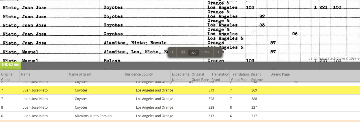
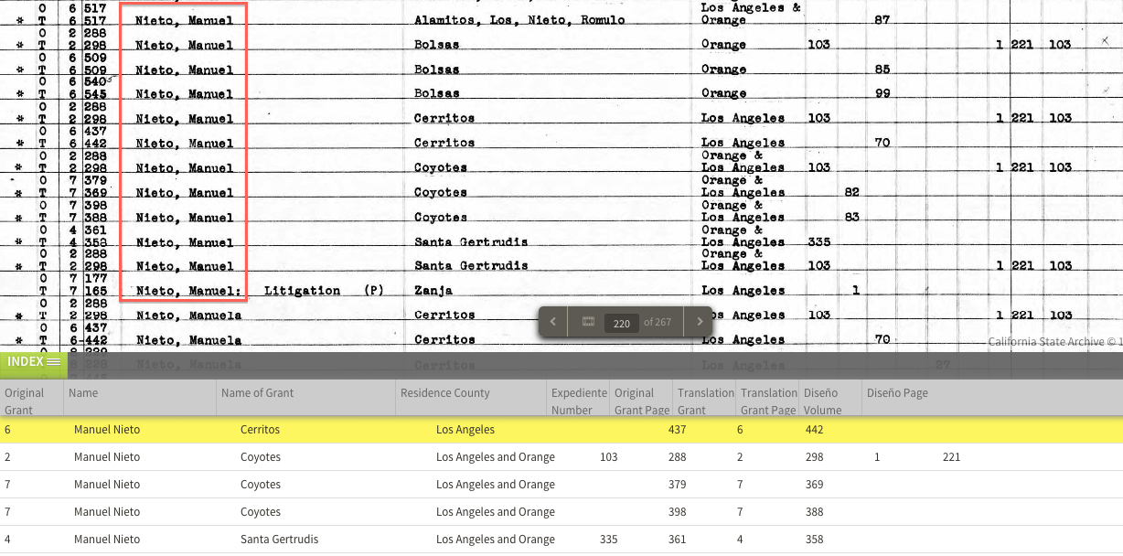
Juan Jose Nieto in the California, Spanish Archive Records, 1784-1868. (Index page 15). Ancestry.com. Click image for a larger view.
2) Jose Antonio Maria Nieto (male):
- Born: 1785.
- Baptized: 14 August 1785 at Mission San Gabriel, Alta California.
- Married: 12 August 1804 at Mission San Gabriel, Alta California.
- Buried: 02 December 1832 at Mission San Gabriel, Alta California.
Spouse: Maria Catarina Ruiz.
1834 Disposition: Las Bolsas (33,460 acres) to widow Maria Catarina Ruiz.
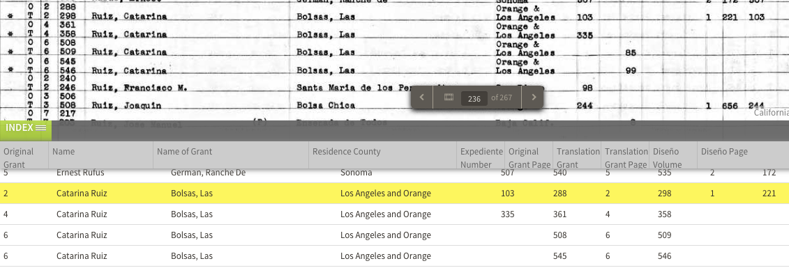
Catarina Ruiz in the California, Spanish Archive Records, 1784-1868. (Index page 38). Ancestry.com. Click image for a larger view.
3) Antonio Maria de los Santos Nieto (male):
- Baptized: 02 November 1788 at Mission San Gabriel, Alta California.
- Married: 25 January 1815 at Mission San Gabriel, Alta California.
- Buried: 07 December 1832 at Mission San Gabriel, Alta California.
Spouse: Maria Josefa Alvina Cota.
1834 Disposition: Santa Gertrudes (21,298 acres) to widow Maria Josefa Alvina Cota.
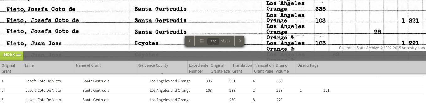
Josefa Coto De Nieto in the California, Spanish Archive Records, 1784-1868. (Index page 15). Ancestry.com. Click image for a larger view.
4) Maria Manuela Antonia Nieto (female):
- Born: 04 August 1791.
- Baptized: 05 August 1791 at Mission San Gabriel, Alta California.
- Married: 14 July 1805 at Mission San Gabriel, Alta California.
Spouse: Guillermo Cota.
1834 Disposition: Los Cerritos (“Little Hills”, 27,054 acres) to Maria Manuela and husband Guillero Cota.
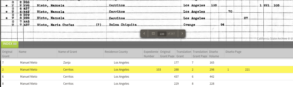
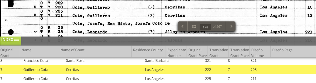
Guillermo Cota in the California, Spanish Archive Records, 1784-1868. (Index page 31). Ancestry.com. Click image for a larger view.
5) Maria de los Santos Nieto (female):
- Born: About 1795 at San Gabriel, Alta California.
- Buried: 28 May 1796 at Mission San Gabriel, Alta California.
6) Antonio Maria Nieto (male):
- Born: 13 July 1796.
- Baptized: 14 July 1796 at Mission San Gabriel, Alta California.
- Buried: 13 December 1804 at Mission San Gabriel, Alta California.
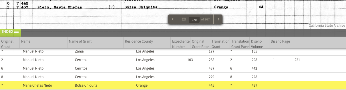
Mystery Heir (Maria Chefas Nieto)
The Spanish Archives Records index lists an additional heir — Maria Chefas Nieto, identified with Bolsa Chiquita. This name does not yet show up in my research database, so she is now on my research radar.
California Ranchos Timeline
Key dates in the history of Alta California and California Ranchos.
- 1769-1821: Spanish rule of Mexico and Alta California.
- 1769-1770: Portolá expedition.
- 1781: Founding of the peublo of Los Angeles.
- 1784: Three earliest Spanish land grants awarded.
- 1821-1848: Mexican rule of Alta California.
- 1821: Mexican Independence.
- 1824: General Colonization Law (allowed foreigners to petition for land).
- 1828: Mexican Reglamento (codified rules for establishing land grants).
- 1835: Secularization of the missions.
- 1846-1848: Mexican-American War.
- U.S. Possession of California (1848- ).
- 1848: Treaty of Guadalupe Hidalgo (February 2).
- 1850: Statehood (September 9).
- 1851: California Land Act of 1851: (ranchos had to reestablish their claims).
Sources
Ancestry.com. California, Spanish Archive Records, 1784-1868 [database on-line]. Provo, UT, USA: Ancestry.com Operations, Inc., 2014. This collection was indexed by Ancestry World Archives Project contributors.
Baker, C. C. (1914). Mexican Land Grants in California. Annual Publication of the Historical Society of Southern California, 9(3), 236–243. doi:10.2307/41168710
County of Orange. (n.d.). Spanish and Mexican Ranchos of Orange County. County of Orange. Retrieved from http://ocarchives.com/civicax/filebank/blobdload.aspx?BlobID=4322
Engstrand, I. H. W. (1985). California Ranchos: Their Hispanic Heritage. Southern California Quarterly, 67(3), 281–290. doi:10.2307/41171160
Milestones in California History. (1988). California History, 67(2). Retrieved from http://www.jstor.org/stable/25177242
Northrop, M. E. (1976). Spanish-Mexican families of early California, 1769-1850. New Orleans: Polyanthos.
Rancho Los Nietos. (2012, June 16). In Wikipedia, The Free Encyclopedia. Retrieved 14:19, February 26, 2015, from http://en.wikipedia.org/w/index.php?title=Rancho_Los_Nietos&oldid=497920500
are you related to beatrice nieto eastwood?
Hi, Spark: We met on Ancestry. Somehow related to Beatrice, as my father tried unsuccessfully to reach her, re: the heirs of Terminal Island, Long Beach, CA, offshore oil rights. Nancy Bareño Paterson
Are you related to Sergeant Manuel Nieto and Paul Manuel Nieto 1906-1994? RIP
You should include Pacifico Ontiveros, son of the foreman Patricio Ontiveros who received Rancho Santa Ana. Pacifico took over, extended the Rancho to the Walnut area and founded the town of Placentia. He later sold 2,000 acres to his son-in-law who formed Anaheim.